Blogs
How ASTERRA Solutions Work Across Several Industries
February 16, 2023

ASTERRA is a company dedicated to observation and discovery in protection of the Earth, its people, and its resources. Our Mission is to “Become humanity’s eyes, guiding it through Earth’s changes.” Using satellite observation of moisture beneath the Earth’s surface, we provide a greater understanding of our signature on the planet and the problems that must be addressed, sometimes quite urgently.
The company now known as ASTERRA first began as part of the search for water on Mars, using remote sensing capabilities that could locate moisture beneath the surface. We adapted that technology for use on our own planet to sense underground leaks in water distribution systems, and in 2013 we founded ASTERRA (first called Utilis). The first commercial use was in 2016.
The technology for detecting leaks in underground water distribution systems was archaic, little changed in 80 years, and so inefficient it was often unusable. Water companies had some idea of how much water they were losing to leaks, but no idea where. Agencies that were losing 33% of everything they processed did not know where to start looking.
With the arrival of ASTERRA, an entire water system, over hundreds of square miles, could be quickly surveyed so that someone could say to the water utility, “Here. Here’s a map to the underground leaks in your system.”
ASTERRA Recover is the name we gave to this unprecedented achievement.
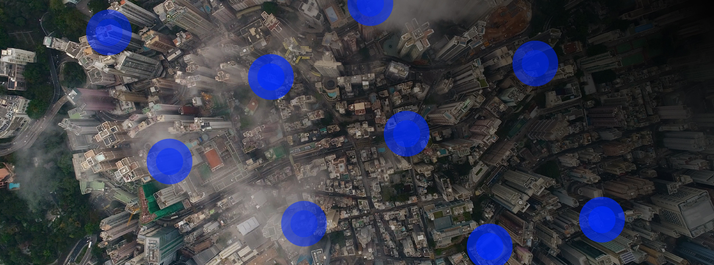
The technology behind ASTERRA Recover, and many ASTERRA applications, begins on a satellite, several satellites, in fact, 390 miles up for a view of over 1000 square miles at once. We deploy synthetic aperture radar, which provides images of a usable resolution over huge swaths of the Earth, and the “L-band” of the electromagnetic spectrum, which can penetrate up to 3 meters below the surface, to locate soil moisture. Basically, we peer down from space and see underground moisture over vast areas at once. This technology has applications across industries.
In the case of Recover, the data it gathers is analyzed by a series of algorithms for the chemical signatures of processed drinking water and overlaid on maps of the underground network, revealing the location of leaks across the entire system. Users of Recover view that information through ASTERRA’s EO Discover portal.
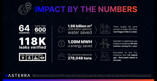
In terms of efficacy, as of 2022, Recover has found and verified over 75,035 leaks and saved 276,129 million gallons of drinking water and the 690,322 MWH of energy it would have taken to replace the water that was lost.
ASTERRA satellite leak detection solutions have been game-changing advances for the utilities and municipal water agencies that deploy them.
Using Recover to take proactive leak detection to a new level, Hilton Head in North Carolina found a completely unknown leak (in a lagoon!) that was losing $500,000 worth of water a year. (We find a lot of “unfindable” leaks.) Irving, Texas found 38 leaks in 7 days instead of the 3+ months it would otherwise have taken. Ohau, Hawaii increased its “leak-finding efficiency” by 400%.
The 400% increase in efficiency is easy to fathom given traditional proactive technology, which is basically using field crews to literally walk the entire system with listening devices. This is impractical for most cities, so reactive methods, like seeing a sinkhole open or a water main burst, were too often used by default. And even major leaks would just continue unseen for years.
By using ASTERRA satellite leak detection solutions, these water agencies and many others around the world have, for the first time, a practical, deployable, affordable way to proactively look for — and find! — underground water system leaks.
EarthWorks is an application of core ASTERRA technology that locates underground soil moisture around and beneath critical infrastructure. Soil moisture near infrastructure is dangerous to ignore, as it can be both an indicator and a cause of catastrophic failure. Just as Recover is to leak detection, EarthWorks is a paradigm shift in Earth observation and infrastructure assessment.
The advantage of EarthWorks is its ability to view huge areas of land at once and regularly review the same spot. It even sees beneath the asphalt covering roads and parking lots. This makes EarthWorks remarkably versatile, offering valuable new capabilities to the mining industry; to the operators of dams and levees; to transportation safety, such as roadways, railways, and runways. And to property managers and developers.
Mining operations are vulnerable to the effects of soil moisture in any number of ways, including its ability to weaken the ‘tailings’ dams that store the toxic waste of mining operations. EarthWorks monitors soil moisture near these dams, under land supporting heavy equipment, and within the dam’s surrounding hills, which excess moisture can bring down on whatever is below.
Moisture seeping through earthen dams and levees can accelerate erosion, lead to ‘piping’, and eventually to failure and collapse. There are 73,000 earthen dams and more than 24,000 miles of levees in the US, with millions of people living in their flood zones. Continuous monitoring by EarthWorks lets managers keep a regular eye on changes to soil moisture to anticipate problems and take preventive action.
Railways and roadways are at risk from soil moisture in several similar ways and have similar assessment challenges. Excess soil moisture under and adjacent to road and rail beds has been a precursor to sinkholes or loss of ground support. And hillsides above and below can collapse as soil moisture accumulates. EarthWorks can assess up to 43 miles of linear infrastructure at once, and penetrate the asphalt over roads, to see where moisture poses a threat.
Large commercial and residential developments are also subject to problems from soil moisture. Paved surfaces from parking lots to runways are subject to ground subsidence and failure from soil moisture, and hillsides are subject to collapse. Property owners and managers anticipate and prevent failure or more serious damage.
By locating and analyzing soil moisture around water systems and critical infrastructure, ASTERRA is fulfilling its vision “…to be better citizens of a more sustainable Earth.” If you want to learn more about ASTERRA satellite leak detection and infrastructure assessment, explore ASTERRA’s solutions or contact us.
Introduction In the realm of machine learning, handling large datasets is a common yet challenging task. My passion for data...
I recently attended a climate adaptation workshop focused on Civil Infrastructure in the UK. One question really stood out: "What...
Transforming the future of our planet is not something ASTERRA and its customers take lightly. ASTERRA, together with our partners...