Blogs
Road Infrastructure Planning: A Comprehensive Guide to Building Better Transportation Systems
June 14, 2023


Road infrastructure planning dates to at least 4000 BCE, when engineered roads were planned and built by the Sumerians of Mesopotamia, now Iraq. That makes roads and highways¹ one of the earliest examples of major infrastructure built to support and expand civilization. Sumerian road planning and building used precisely manufactured mud bricks set in place with an oozy, sticky form of petroleum called bitumen as a durable, water-resistant adhesive. The Sumerians were on to something. We still use bitumen today.
What’s different today are the vehicles, faster and heavier than anything the Sumerians might have imagined, which is one of the major factors determining modern road design.
Highway infrastructure planning and construction is unique among civil engineering projects in that nearly everyone throughout the world gets to experience its principal design elements firsthand. Roads are everywhere. Whether we are drivers, passengers, bikers, cyclists, pedestrians, residents, businesses, or even wildlife, road planning and highway construction profoundly impact our daily lives. These are some of the major elements of road infrastructure planning that make safe driving possible:
Site Distance. The distance at which an object on the road becomes visible
Horizontal Alignment. The straight or curved path the road takes.
Vertical Alignment and Grade. The changing elevation of the road and the steepness of the climb or descent.
Superelevation. The sideways slope of a road inward through a curve to counteract centrifugal forces that would tend to send us flying.
The majority of U.S. roads are made of asphalt, and about 30 percent are made of concrete. Gravel and earth are also used as road surfaces, particularly in rural, agricultural, or industrial settings, such as mining operations. Each material offers pros and cons.
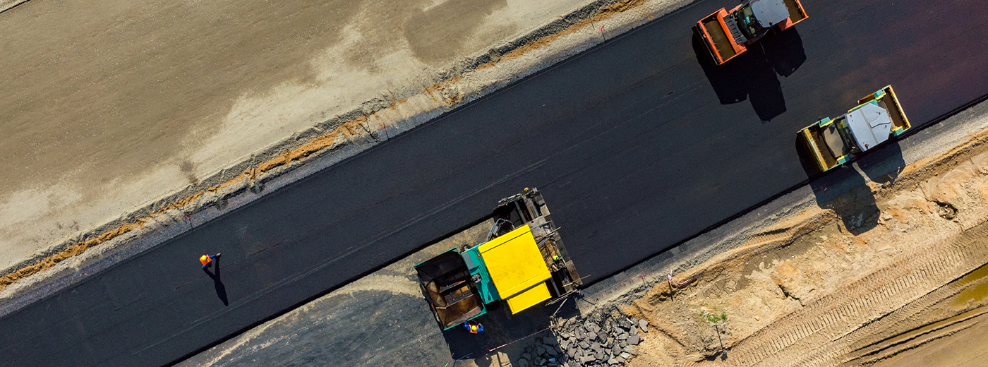
Asphalt is an aggregate of rock and sand bound together with bitumen, just as the Sumerians recommended. Heating it to around 300° F liquifies it enough to pour into the roadbed and then compact with a steam roller. Up to four layers may be used.
Asphalt is a popular choice for many reasons, including fast application, good wet and dry traction, and low cost to install and maintain/repair. The expected life span is 15 – 20 years, and the material is recyclable. One downside of asphalt is that, in a time of climate change, severe heat can soften the road surface.
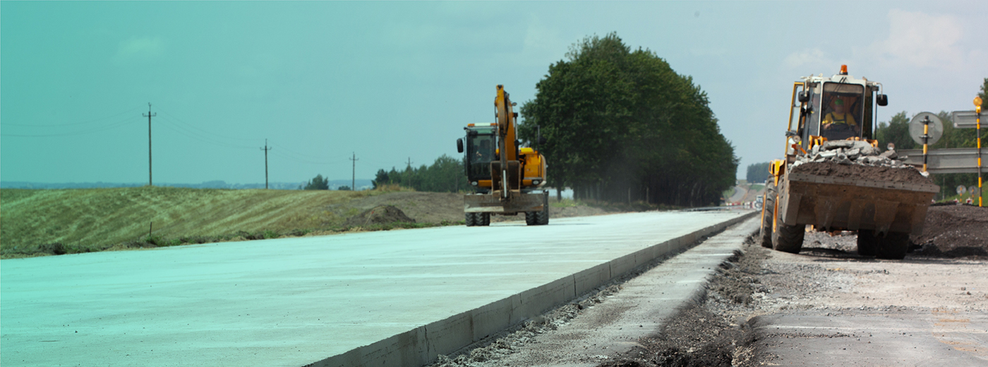
Concrete roads in highway construction are extremely durable and can last 20 – 40 years, even bearing the weight of 80,000 lb big rigs. Unlike asphalt, concrete doesn’t soften in the heat. It’s less widely used², however, due largely to the time and cost of installation. Repairs won’t be needed as often, but when they are, those costs are much higher as well. It’s also noisier and lacks asphalt’s built-in traction.
Gravel and earthen (or dirt) roads can be installed much faster and at less cost than asphalt or concrete, but they lack durability. Dirt roads are easily damaged by water and offer little natural traction. Gravel roads have even less traction, limiting the speed and types of vehicles that can use them. Gravel needs to be replenished regularly.
In planning the location and horizontal alignment (path) of the road, tests are conducted to determine if the soil underneath is dry and stable enough to handle the weight and activity above. Tests include soil classification, particle size distribution, moisture content, specific gravity, and liquid limit, for example.
One of the first steps in the actual construction is to prepare the bottom layer of the roadbed or subgrade by removing the topsoil and any vegetation. The subgrade should be graded (sloping downward from the center on both sides) to allow water to drain. Finally, it’s compacted under a heavy roller.
For asphalt roads, a subbase made of aggregate is applied on top of the subgrade to provide additional support and strength. Once the various layers of asphalt are poured and compacted, they should be ready for traffic within 24 hours or so.
With concrete roads, once the subbase is applied, a wooden or metal framework is built. Rebar (steel reinforcing bar) may be embedded to improve strength. Once the concrete is poured, it can take up to a week to fully cure and dry for use.
There are approximately 4.1 million³ miles of paved roads in the United States and 1.3 million miles of unpaved roads. The need for highway infrastructure planning, construction, and maintenance is greater than ever. According to the American Society of Civil Engineers⁴, 43% of those roads are in “poor or mediocre” condition. About 15% are considered in “fair” condition, with 42% rated as ‘good’. Many roads are operating at or near capacity, with congestion a growing problem.
Managing water both above and below the road surface is a primary engineering consideration in road infrastructure planning.
In determining the horizontal alignment, the subgrade optimum moisture content (OMC) that’s needed generally ranges from 10% – 20%, depending on the soil classification. Too dry and it won’t compact, too wet and it won’t be stable. And so it must be assessed prior to construction.
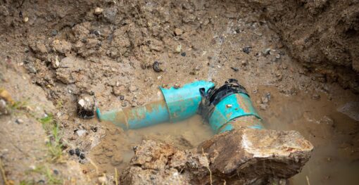
Once the road is built, water that falls on the road surface has to go someplace (which is why roads are generally graded down from the center), or driving in the rain would be unsafe. And constant standing water will eventually destroy the road as it percolates through the pavement and weakens the soil below, which leads to cracks above, then even more soil moisture below, then more damage to the surface, and even more seepage, until eventual failure.
If a road is situated above or below a hill, excess soil moisture can cause the hill to collapse and the road with it. In 2023, a moisture-soaked hillside slid onto Interstate 5⁵, closing California’s main N/S highway for a time.
Water from other sources can also flow through the soil underneath, erode it away, and lead to sinkholes, which are probably the most dramatic impact of moisture on roads. In 2023, in Minneapolis, a large sinkhole opened up when a 120-year-old sewer pipe⁶ collapsed. Also in 2023, in Plumas County, CA, a sudden sinkhole caused by moisture nearly swallowed a utility truck⁷ and the highway had to be closed.
Unfortunately, there is no national database of sinkholes. But according to the U.S. Geological Survey⁸, “Sinkholes are most common in what geologists call, ‘karst terrain…”, where rocks below the surface can be dissolved naturally by circulating groundwater. The cost of sinkholes is estimated at $300 million a year, though is likely much higher.
In most cases, a better understanding of moisture conditions below the surface prior to an event would have been extremely helpful in anticipating and perhaps preventing these failures.
The ability to detect and analyze soil moisture under roadways or roads that are being planned is essential to maintaining safe and reliable highway infrastructure. EarthWorks detects soil moisture up to 40 linear miles at a glance, and three (3) meters below the surface, even through asphalt.
EarthWorks generates soil moisture maps (viewed through ASTERRA’s EO Discover platform) that can help anticipate future sinkholes, collapsed hillsides, and other threats to road and highway infrastructure. For road planning, it provides data on soil moisture far more efficiently than field work alone.
Learn more about ASTERRA EarthWorks and how it helps ensure the safety of roads and highways by detecting and analyzing excess soil moisture.
¹ https://highways.dot.gov/highway-history/general-highway-history/back-time/building-roads
² https://housegrail.com/asphalt-vs-concrete-road/
³ https://www.bts.gov/content/public-road-and-street-mileage-united-states-type-surfacea
⁴ https://infrastructurereportcard.org/cat-item/roads-infrastructure/
⁵ https://www.latimes.com/environment/story/2023-01-14/hillside-collapse-damages-portion-of-the-5-repairs-underway
⁶ https://www.startribune.com/large-sinkholes-could-be-more-the-norm-as-minneapolis-pipes-age/600280398
⁷ https://www.plumasnews.com/sinkhole-or-culvert-failure-regardless-it-closes-a-portion-of-hwy-70/
⁸ https://www.usgs.gov/faqs/what-a-sinkhole

Municipal water systems across the globe face an invisible crisis that drains billions from public coffers annually. Water losses from...

Water security represents one of the most pressing challenges of the 21st century, with global water demand projected to increase...
Urban infrastructure systems are the backbone of modern society, enabling clean water distribution, waste removal, and the overall health and...